

| FAQ |
| Calendar |

|
|
|||||||


| Elektronik lainnya Khusus elektronik yang tidak ada di kategori |
 |
|
|
Thread Tools |
|
#1
 23rd October 2012
|
||||
|
||||
|
Kondisi Barang : Baru
Harga : Lokasi Seller : DKI Jakarta Description : Garmin eTrex 20 + Peta Indonesia Harga : Rp.2.500.000,-  eTrex 20 takes one of the most popular and reliable GPS handhelds and makes it better. Redesigned ergonomics, an easier-to-use interface, paperless geocaching and expanded mapping capabilities add up to serious improvements for an already legendary GPS handheld. eTrex 20 is versatile. It's tough. And it�s built to handle whatever Mother Nature can dish out � and more. eTrex minisite See The Way eTrex 20 has an enhanced 2.2 in 65K color, sunlight readable display. Durable and waterproof, eTrex 20 is built to withstand the elements. It has an upgraded interface yet retains its legendary toughness to withstand the elements � be it dust, dirt, humidity or water, none of which are a match for this storied navigator. Go Anywhere With an array of compatible mounts, eTrex 20 is designed for use on ATV�s, bicycles, in boats, as a handheld or in your car. Use the auto mount capability and City Navigator NT� maps for turn-by-turn driving directions, or the rugged mount for your motorcycle or ATV. Wherever you think you might take eTrex, it has the mapping and mounts to get you there. Go Global The new eTrex series is the first-ever consumer-grade receivers that can track both GPS and GLONASS satellites simultaneously. GLONASS is a system developed by the Russian Federation that will be fully operational in 2012. When using GLONASS satellites, the time it takes for the receiver to �lock on� to a position is (on average) approximately 20 percent faster than using GPS. And when using both GPS and GLONASS, the receiver has the ability to lock on to 24 more satellites than using GPS alone. Add Maps With its microSD� card slot and 1.7 GB of internal memory, eTrex 20 lets you load TOPO 24K maps and hit the trail, plug in BlueChart� g2 preloaded cards for a great day on the water or City Navigator NT� map data for turn-by-turn routing on roads (see maps tab for compatible maps). eTrex 20 also supports BirdsEye� Satellite Imagery (subscription required), that lets you download satellite images to your device and integrate them with your maps. Keep Your Fix With its high-sensitivity, WAAS-enabled GPS receiver and HotFix� satellite prediction, eTrex locates your position quickly and precisely and maintains its GPS location even in heavy cover and deep canyons. Find Fun eTrex 20 supports geocaching GPX files for downloading geocaches and details straight to your unit. Visit OpenCaching.com to start your geocaching adventure. By going paperless, you're not only helping the environment but also improving efficiency. eTrex 20 stores and displays key information, including location, terrain, difficulty, hints and descriptions, which means no more manually entering coordinates and paper print outs. Simply upload the GPX file to your unit and start hunting for caches. Physical & Performance: Unit dimensions, WxHxD: 2.1" x 4.0" x 1.3" (5.4 x 10.3 x 3.3 cm) Display size, WxH: 1.4" x 1.7" (3.5 x 4.4 cm); 2.2" diag (5.6 cm) Display resolution, WxH: 176 x 220 pixels Display type: transflective, 65-K color TFT Weight: 5 oz (141.7 g) with batteries Battery: 2 AA batteries (not included); NiMH or Lithium recommended Battery life: 25 hours Waterproof: yes (IPX7) Floats: no High-sensitivity receiver: yes Interface: USB Maps & Memory: Basemap: yes Preloaded maps: no Ability to add maps: yes Built-in memory: 1.7 GB Accepts data cards: microSD� card (not included) Waypoints/favorites/locations: 2000 Routes: 200 Track log: 10,000 points, 200 saved tracks Features & Benefits: Automatic routing (turn by turn routing on roads): yes (with optional mapping for detailed roads) Electronic compass: no Touchscreen: no Barometric altimeter: no Camera: no Geocaching-friendly: yes (paperless) Custom maps compatible: yes Photo navigation (navigate to geotagged photos): yes Outdoor GPS games: no Hunt/fish calendar: yes Sun and moon information: yes Tide tables: yes Area calculation: yes Custom POIs (ability to add additional points of interest): yes Unit-to-unit transfer (shares data wirelessly with similar units): no Picture viewer: no Garmin Connect� compatible (online community where you analyze, categorize and share data): yes What's in the Box: eTrex 20 USB cable Manual Gambar : [/spoiler][spoiler=open this] for option: 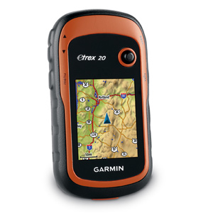 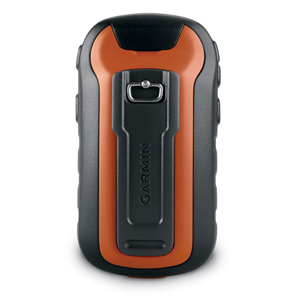 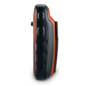  untuk stock terbatas jika berminat silahkan hubungi kami di : Jl. Raya Fatmawati 26i, Pondok Labu Jakarta Selatan, 12450 Call/SMS: 08999993622 Call: 021-68144441/68502548 Terima Kasih Riyan 
|
|
|
|


