

| FAQ |
| Calendar |

|
|
|||||||


| Elektronik lainnya Khusus elektronik yang tidak ada di kategori |
 |
|
|
Thread Tools |
|
#1
 23rd October 2012
|
||||
|
||||
|
Kondisi Barang : Baru
Harga : Lokasi Seller : DKI Jakarta Description : 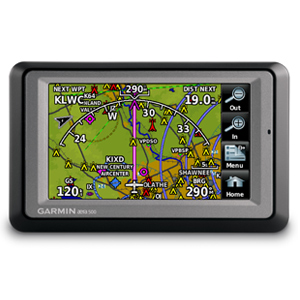 Garmin�s aera series of dual-duty GPS portables offer easy transition from flying to motoring � by combining the best in moving-map display features with intuitive, menu-driven touchscreen control. With aera, fingertip navigation has entered a whole new era: One that streamlines operation. Eliminates knobs and buttons. Simplifies the pilot/motorist interface. And lets you think in terms of door-to-door guidance, not just runway-to-runway. Check Out the aera 500 There are four aera models in the Garmin lineup, offering a full range of cost/capability choices. The first and most affordable unit in the series is the aera 500. Featuring a crisp 4.3-inch QVGA wide-format touchscreen and pre-loaded graphical mapping, this versatile, feature-rich unit comes ready for takeoff, right out of the box. Fly aera. Anywhera In aviation mode, the aera 500�s detailed chart-style shaded mapping and extensive terrain and aviation databases help you visualize your flight path in relation to nearby navaids, terrain, SUAs, obstructions, and so on. To help keep pilots aware of special airspace activity, over 683 parachute drop zones are detailed in the Americas navigation database. Plus, the addition of private airports and heliports to the database affords even more navigation and emergency �nearest� options. A database-driven terrain advisory feature offers TAWS-like color coding and pop-up alerts when possible obstructions or ground proximity conflicts loom ahead. And with terrain/obstacle data shown at standard 30 arc-second resolution, you�ll enjoy a surprising level of detail on the display. The unit�s graphical Terrain page offers both overhead and vertical profile views of the topography you�re flying over. What�s more, there�s an IFR map mode that lets you display and navigate on high or low enroute airways. You can also pull up MEAs (Minimum Enroute Altitudes) and distances between intersections by touching the airway on the map. As in all the aera models, the internal GPS updates at a rate of five times per second (5 Hz), which allows your moving map and flight data to display smoothly and continuously. And for added safety, an optional power/data cable (sold separately) makes it easy to interface your aera 500 with the Garmin GTX 330 Mode S transponder in your aircraft, so you can access and display TIS traffic alerts in busy terminal airspace. What�s more, you can also use the aera to load communications frequencies into your Garmin SL 40 Comm or SL 30 Nav/Comm transceiver. Built to Fly. Born to Run Once your aircraft returns to terra firma, the fun of aera navigation continues with full automotive GPS capability and preloaded City Navigator� NT street mapping. Operating much like Garmin�s popular n�vi� line of touchscreen auto navigators, your aera 500 offers voice-guided turn-by-turn directions with text-to-speech audio technology that calls out streets by name. In addition, there�s built-in Bluetooth� support for wireless hands-free calling with your compatible mobile phone. And the aera�s built-in �points of interest� database offers helpful guidance to millions of motels, restaurants, gas stations, ATMs, and other local attractions. To further speed your transition from aircraft to automotive mode, a unique �smart mount� for the aera offers instant clip-and-go car navigation. Garmin aera series: It�s the ultimate fly/drive option. [/spoiler][spoiler=open this] for Gambar: 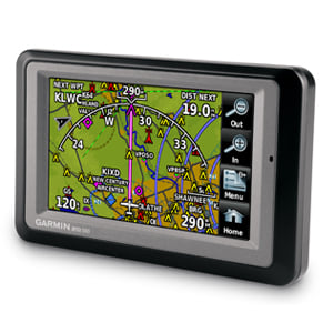 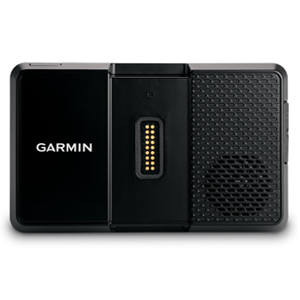 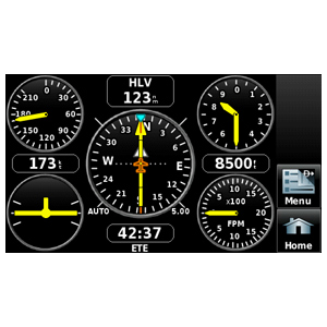 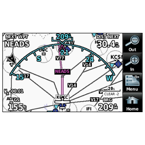 Physical & Performance: Unit dimensions, WxHxD: 5.3"W x 3.3"H x .9"D (13.5 x 8.4 x 2.3 cm) Display size, WxH: 3.81"W x 2.25"H (9.7 x 5.7 cm); 4.3" diag (10.9 cm) Display resolution, WxH: 480 x 272 pixels Display type: touchscreen WQVGA color TFT with white backlight Weight: 9.5 ounces (270 g) Battery: removable, rechargeable lithium-ion Battery life: up to 5 hours (less with full backlight and options) Waterproof: yes (IPX7) Voltage range: 11-35 SBAS/WAAS receiver: high-sensitivity with WAAS position accuracy IFR or VFR: VFR Maps, Databases & Memory: Basemap: yes Navigation database (includes Jeppesen� data): yes Types of Jeppesen data: full and ARTCC, FSS frequencies and final approach waypoints Navigation database coverage areas: Americas or Atlantic or Pacific Preloaded Terrain database: yes Preloaded Obstacle database: yes (U.S. and Europe only) Preloaded SafeTaxi� airport diagrams: not available Preloaded AOPA Airport Directory: not available Preloaded Garmin FliteCharts�: no Preloaded low & high altitude enroute airways: yes Preloaded private airports: yes (U.S. only) Preloaded street maps: yes Ability to add maps: yes Accepts data cards: yes (microSD� cards) Built-in memory: internal solid state Waypoints/favorites/locations: 3,000 (aviation mode); 1,000 (automotive mode) Routes: 50 Features & Benefits: Moving map: yes Patented panel page: yes HSI (GPS-based): yes IFR map mode: yes Traffic Information Services (TIS) alerts compatible: yes Audible terrain alerts: yes Terrain resolution: standard Smart Airspace Feature (generates and displays altitude-sensitive alerts): yes Automatic logbook: yes Separate serial and USB interfaces: yes Voice prompts (e.g. "Turn right in 500 ft."): yes (auto mode) Speaks street names (e.g. "Turn right ON ELM STREET in 500 ft."): yes (auto mode) Lane assist (guides to proper lane for navigation): no 3-D map view: yes (auto mode) Bluetooth� wireless technology: yes (auto mode) Speed limit indicator (displays speed limit for most major roads in the U.S. and Europe): no Traffic compatible (routes around traffic with a receiver and subscription): no Custom POIs (ability to add additional points of interest): yes (auto mode) XM WX Weather & Radio for U.S. & Canada compatible: no What's in the Box: aera 500 Free single database update Yoke mount with power cable Battery pack Portable friction mount USB cable Vehicle power cable Pilot's guide and owner's manual Ym; otomasi8 OTOMASI Online Shop - GPS Garmin, GPS Tomtom, GPS Indonesia, Alat Survey, Total Station, Theodolite, Alat Komunikasi, Peta Indonesia, Jam Tangan, Aksesories OTOMASI ONLINE SHOP Kantor Pusat: Jl. Raya Fatmawati 26i, Pondok Labu Jakarta Selatan, 12450 Call/SMS: 08999993622 Call: 021-68144441/68502548 (flexy) 
|
|
|
|


