

| FAQ |
| Calendar |

|
|
|||||||


| Elektronik lainnya Khusus elektronik yang tidak ada di kategori |
 |
|
|
Thread Tools |
|
#1
 23rd October 2012
|
||||
|
||||
|
Kondisi Barang : Baru
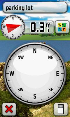
Harga : Lokasi Seller : DKI Jakarta Description : Garmin Oregon 550i + microSD 2Gb + Peta Jalan & Topografi Indonesia  The navigator with the photographic memory � Oregon 550 combines rugged outdoor touchscreen navigation with a digital camera. It is perfect for all activities, in any climate, on any terrain, yet simple enough for beginners to master. Take Pictures and Save Locations Oregon 550's 3.2 megapixel autofocus digital camera with 4x digital zoom automatically. geotags each photo with the location of where it was taken, allowing you to mark, remember and navigate back to that exact spot in the future. You can take and view pictures in landscape or portrait, and 850 MB of internal memory offers ample storage. Connect Oregon 550 via USB and log into my.Garmin.com to upload and store your photos at Picasa�, a popular online photo sharing community Touch and Go Oregon 550 has a tough, 3-inch diagonal, sunlight-readable, colour touchscreen display with a simple-to-use menu system. Both durable and waterproof, Oregon 550 is built to withstand the elements. Get Your Bearings Oregon 550 has a built-in 3-axis tilt-compensated electronic compass, which shows your heading even when you�re standing still, without holding it level. Its barometric altimeter tracks changes in pressure to pinpoint your precise altitude. With high-sensitivity, WAAS-enabled GPS receiver and HotFix� satellite prediction, Oregon 550 locates your position quickly and precisely and maintains its GPS location even in heavy cover and urban landscapes. Add Maps Oregon 550 comes preloaded with a worldwide built-in basemap with shaded relief. You can add maps for walking, driving and for use out on the water. On the trail a TOPO GB DVD or Garmin GB Discoverer� microSD card gives topographic and Ordnance Survey map detail, showing terrain contours, summits, trails and more. On the road you can add Garmin GB Discoverer� or City Navigator mapping for detailed street maps and turn-by-turn directions to your destination. On the water you can add BlueChart� g2 maps which provide information such as depth contours, full charting and harbours. Go Geocaching Go paperless with Oregon 550 by quickly downloading information from Geocaching.com for up to 5000 caches, such as location, terrain, difficulty, hints and description. Use for running or cycling The Oregon is compatible with Garmin�s heart-rate monitors and speed/cadence sensors and can track your speed, distance, elevation and location. Share Wirelessly With Oregon 550 you can share your waypoints, tracks, routes and geocaches wirelessly other Oregon and Colorado users. Now you can send your favorite route to a friend to enjoy or the location of a cache to find. Sharing data is easy. Just touch "send" to transfer your information to similar devices. [/spoiler] Spoiler for open this:
Spoiler for open this:
    Ym; otomasi8 http://otomasi.com/index.php OTOMASI ONLINE SHOP Kantor Pusat: Jl. Raya Fatmawati 26i, Pondok Labu Jakarta Selatan, 12450 Call/SMS: 08999993622 Call: 021-68144441/68502548 (flexy) Terkait:

|
|
|
|


