

| FAQ |
| Calendar |

|
|
|||||||


| Gadget dan Aksesoris Khusus jual beli gadget dan aksesorisnya |
 |
|
|
Thread Tools |
|
#1
 7th November 2012
|
|||
|
|||
|
Kondisi Barang : Baru
Harga : Lokasi Seller : DKI Jakarta Description : ASSALAMUALAIKUM.... SOLD ane buka lapak nih..... kali ini jualan GPS MAP GARMIN 76CSx masih mulus kinyis-kinyis.... murah meriah sekaskus....silahkan dibandingin.... nih pic-nya 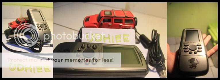 keterangan... -barang mulus -cocok untuk petualang.... -anti air -keren dah..... minus : - no box harga : sold kontak : 085228107411 (udhie) sms/tlp fast respon transaksi : COD (jaksel,BSD,serpong) area laen bisa janjian... kirim-kirim juga silahkan...ongkir tanggung buyer yahh... info tambahan GPSMAP 76CSx: Color navigation and direction for your land and sea adventures WAAS enabledBlueChart compatibleGeocaching readySiRF Physical & Performance: Unit dimensions, WxHxD: 2.7" x 6.2" x 1.2" (6.9 x 15.7 x 3.0 cm) Display size, WxH: 1.6" x 2.2" (4.1 x 5.6 cm) Display resolution, WxH: 160 x 240 pixels Display type: 256 color transflective TFT Weight: 7.7 oz (218 g) with batteries Battery: 2 AA batteries (not included) Battery life: 18 hours, typical Waterproof: yes (IPX7) Floats: yes High-sensitivity receiver: yes Interface: serial and USB RoHS version available: yes Maps & Memory: Basemap: yes Preloaded maps: no Ability to add maps: yes Built-in memory: none (cannot load maps to internal memory) Accepts data cards: microSD� card Waypoints/favorites/locations: 1000 Routes: 50 Track log: 10,000 points; 20 saved tracks Features: Automatic routing (turn by turn routing on roads): yes Electronic compass: yes Barometric altimeter: yes Geocaching-friendly: yes Outdoor GPS games: yes Hunt/fish calendar: yes Sun and moon information: yes Tide tables: yes Area calculation: yes Custom POIs (ability to add additional points of interest): yes Unit-to-unit transfer (shares data wirelessly with similar units): no Picture viewer: no 
|
|
|
|


